2004 Indian Ocean earthquake and tsunami

Aceh in Indonesia, the most devastated region struck by the tsunami
| |
| Date | 26 December 2004[1] |
|---|---|
| Origin time | 00:58 UTC |
| Magnitude | 9.1–9.3 Mw[2] |
| Depth | 30 km (19 mi)[1] |
| Epicenter | 3.316°N 95.854°E [1] |
| Type | Megathrust |
| Areas affected | Indonesia Sri Lanka India Thailand Maldives Somalia |
| Max. intensity | IX (Violent)[1] |
| Tsunami | 51 metres (200 ft)[3] |
| Casualties | 230,000–280,000 dead and more missing[4][5][6][7] |

The 2004 Indian Ocean earthquake occurred at 00:58:53 UTC on 26 December with the epicentre off the west coast of Sumatra, Indonesia. The shock had a moment magnitude of 9.1–9.3 and a maximum Mercalli intensity of IX (Violent). The underseamegathrust earthquake was caused when the Indian Plate was subducted by the Burma Plate and triggered a series of devastating tsunamis along the coasts of most landmasses bordering the Indian Ocean, killing 230,000 people in 14 countries, and inundating coastal communities with waves up to 30 metres (100 ft) high. It was one of the deadliest natural disasters in recorded history. Indonesia was the hardest-hit country, followed by Sri Lanka, India, and Thailand.
It is the third-largest earthquake ever recorded on a seismograph and had the longest duration of faulting ever observed, between 8.3 and 10 minutes. It caused the entire planet to vibrate as much as 1 centimetre (0.4 inches) and triggered other earthquakes as far away as Alaska. Its epicentre was between Simeulue and mainland Indonesia. The plight of the affected people and countries prompted a worldwide humanitarian response. In all, the worldwide community donated more than US$14 billion (2004) in humanitarian aid. The event is known by the scientific community as the Sumatra–Andaman earthquake. The resultingtsunami was given various names, including the 2004 Indian Ocean tsunami, South Asian tsunami, Indonesian tsunami, theChristmas tsunami and the Boxing Day tsunami.
Earthquake characteristics
| 2004 Indian Ocean earthquake | |
 | |
Animation of tsunami caused by the earthquake showing how it
radiated from the entire length of the 1,600 km (990 mi) rupture Events
Response
See also
| |
The earthquake was initially documented as moment magnitude 8.8. In February 2005 scientists revised the estimate of the magnitude to 9.0. Although the Pacific Tsunami Warning Center has accepted these new numbers, the United States Geological Survey has so far not changed its estimate of 9.1. The most recent studies in 2006 have obtained a magnitude of Mw 9.1–9.3. Dr. Hiroo Kanamori of the California Institute of Technology believes that Mw 9.2 is a good representative value for the size of this great earthquake.
The hypocentre of the main earthquake was approximately 160 km (100 mi) off the western coast of northern Sumatra, in the Indian Ocean just north of Simeulue island at a depth of 30 km (19 mi) below mean sea level (initially reported as 10 km (6.2 mi)). The northern section of the Sunda megathrust ruptured over a length of 1,300 km (810 mi). The earthquake (followed by the tsunami) was felt simultaneously in Bangladesh, India, Malaysia, Myanmar, Thailand, Singapore and theMaldives. Splay faults, or secondary "pop up faults", caused long, narrow parts of the sea floor to pop up in seconds. This quickly elevated the height and increased the speed of waves, causing the complete destruction of the nearby Indonesian town of Lhoknga.


Indonesia lies between the Pacific Ring of Fire along the north-eastern islands adjacent to New Guinea, and the Alpide beltthat runs along the south and west from Sumatra, Java, Bali, Flores to Timor.
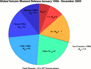
Great earthquakes such as the Sumatra-Andaman event, which are invariably associated with megathrust events insubduction zones, have seismic moments that can account for a significant fraction of the global earthquake moment across century-scale time periods. Of all the seismic moment released by earthquakes in the 100 years from 1906 through 2005, roughly one-eighth was due to the Sumatra-Andaman event. This quake, together with the Good Friday earthquake (Alaska, 1964) and the Great Chilean earthquake (1960), account for almost half of the total moment. The much smaller but still catastrophic 1906 San Francisco earthquake is included in the diagram for perspective. Mw denotes the magnitude of an earthquake on the moment magnitude scale.
Since 1900 the only earthquakes recorded with a greater magnitude were the 1960 Great Chilean earthquake (magnitude 9.5) and the 1964 Good Friday earthquake in Prince William Sound (9.2). The only other recorded earthquakes of magnitude 9.0 or greater were off Kamchatka, Russia, on 4 November 1952 (magnitude 9.0) and Tōhoku, Japan (magnitude 9.0) in March 2011. Each of these megathrust earthquakes also spawned tsunamis in the Pacific Ocean. However, the death toll from these was significantly lower, primarily because of the lower population density along the coasts near affected areas and the much greater distances to more populated coasts and also due to the superior infrastructure and warning systems in MEDCs (More Economically Developed Countries) such as Japan.
Other very large megathrust earthquakes occurred in 1868 (Peru, Nazca Plate and South American Plate); 1827 (Colombia, Nazca Plate and South American Plate); 1812 (Venezuela, Caribbean Plate and South American Plate) and 1700 (western North America, Juan de Fuca Plate and North American Plate). All of them are believed to be greater than magnitude 9, but no accurate measurements were available at the time.
Foreshock
The 2002 Sumatra earthquake is believed to have been a foreshock, predating the main event by over two years.
Tectonic plates
The megathrust earthquake was unusually large in geographical and geological extent. An estimated 1,600 kilometres (1,000 mi) of fault surface slipped (or ruptured) about 15 metres (50 ft) along the subduction zone where the Indian Plate slides (or subducts) under the overriding Burma Plate. The slip did not happen instantaneously but took place in two phases over a period of several minutes:
- Seismographic and acoustic data indicate that the first phase involved a rupture about 400 kilometres (250 mi) long and 100 kilometres (60 mi) wide, located 30 kilometres (19 mi) beneath the sea bed—the largest rupture ever known to have been caused by an earthquake. The rupture proceeded at a speed of about 2.8 kilometres per second (1.7 miles per second) (10,000 km/h or 6,200 mph), beginning off the coast of Aceh and proceeding north-westerly over a period of about 100 seconds.
- A pause of about another 100 seconds took place before the rupture continued northwards towards the Andaman and Nicobar Islands. However, the northern rupture occurred more slowly than in the south, at about 2.1 km/s (1.3 mi/s) (7,500 km/h or 4,700 mph), continuing north for another five minutes to a plate boundary where the fault type changes from subduction to strike-slip (the two plates slide past one another in opposite directions).
The Indian Plate is part of the great Indo-Australian Plate, which underlies the Indian Ocean and Bay of Bengal, and is drifting north-east at an average of 6 centimetres per year (2.4 inches per year). The India Plate meets the Burma Plate (which is considered a portion of the great Eurasian Plate) at the Sunda Trench. At this point the India Plate subducts beneath the Burma Plate, which carries the Nicobar Islands, the Andaman Islands, and northern Sumatra. The India Plate sinks deeper and deeper beneath the Burma Plate until the increasing temperature and pressure drive volatiles out of the subducting plate. These volatiles rise into the overlying plate causing partial melting and the formation of magma. The rising magma intrudes into the crust above and exits the Earth's crust through volcanoes in the form of a volcanic arc. The volcanic activity that results as the Indo-Australian Plate subducts the Eurasian Plate has created the Sunda Arc.
As well as the sideways movement between the plates, the sea floor is estimated to have risen by several metres, displacing an estimated 30 cubic kilometres (7.2 cu mi) of water and triggering devastating tsunami waves. The waves did not originate from a point source, as was inaccurately depicted in some illustrations of their paths of travel, but rather radiated outwards along the entire 1,600-kilometre (1,000 mi) length of the rupture (acting as a line source). This greatly increased the geographical area over which the waves were observed, reaching as far as Mexico, Chile, and the Arctic. The raising of the sea floor significantly reduced the capacity of the Indian Ocean, producing a permanent rise in the global sea level by an estimated 0.1 millimetres (0.004 in).
Aftershocks and other earthquakes

Numerous aftershocks were reported off the Andaman Islands, the Nicobar Islands and the region of the original epicentre in the hours and days that followed. The magnitude 8.7 2005 Nias–Simeulue earthquake, which originated off the coast of the Sumatran island of Nias, is not considered an aftershock, despite its proximity to the epicenter, and was most likely triggered by stress changes associated with the 2004 event. This earthquake was so large that it produced its own aftershocks (some registering a magnitude of as great as 6.1) and presently ranks as the 7th largest earthquake on record since 1900.
Other aftershocks of up to magnitude 6.6 continued to shake the region daily for up to three or four months. As well as continuing aftershocks, the energy released by the original earthquake continued to make its presence felt well after the event. A week after the earthquake, its reverberations could still be measured, providing valuable scientific data about the Earth's interior.
The 2004 Indian Ocean earthquake came just three days after a magnitude 8.1 earthquake in an uninhabited region west of New Zealand's subantarctic Auckland Islands, and north of Australia's Macquarie Island. This is unusual, since earthquakes of magnitude 8 or more occur only about once per year on average. However, the U.S. Geological Survey sees no evidence of a causal relationship between these events.
The December earthquake is thought to have triggered activity in both Leuser Mountain and Mount Talang, volcanoes in Aceh province along the same range of peaks, while the 2005 Nias–Simeulue earthquake had sparked activity in Lake Toba, an ancient crater in Sumatra.
Energy released

The energy released on the Earth's surface only (ME, which is the seismic potential for damage) by the 2004 Indian Ocean earthquake and tsunami was estimated at 1.1×10¹⁷ joules, or 26 megatons of TNT. This energy is equivalent to over 1500 times that of the Hiroshima atomic bomb, but less than that of Tsar Bomba, the largest nuclear weapon ever detonated. However, the totalwork done MW (and thus energy) by this quake was 4.0×10²² joules (4.0×1029 ergs),the vast majority underground. This is over 360,000 times more than its ME, equivalent to 9,600 gigatons of TNT equivalent (550 million times that of Hiroshima) or about 370 years of energy use in the United States at 2005 levels of 1.08×10²⁰ J.
The only recorded earthquakes with a larger MW were the 1960 Chilean and 1964 Alaskan quakes, with 2.5×10²³ joules (250 ZJ) and 7.5×10²² joules (75 ZJ) respectively.
The earthquake generated a seismic oscillation of the Earth's surface of up to 20–30 cm (8–12 in), equivalent to the effect of the tidal forces caused by the Sun and Moon. The shock waves of the earthquake were felt across the planet; as far away as the U.S. state ofOklahoma, where vertical movements of 3 mm (0.12 in) were recorded. By February 2005, the earthquake's effects were still detectable as a 20 µm (0.02 mm; 0.0008 in) complex harmonic oscillation of the Earth's surface, which gradually diminished and merged with the incessant free oscillation of the Earth more than 4 months after the earthquake.
Because of its enormous energy release and shallow rupture depth, the earthquake generated remarkable seismic ground motions around the globe, particularly due to huge Rayleigh (surface) elastic waves that exceeded 1 cm (0.4 in) in vertical amplitude everywhere on Earth. The record section plot displays vertical displacements of the Earth's surface recorded by seismometers from the IRIS/USGS Global Seismographic Network plotted with respect to time (since the earthquake initiation) on the horizontal axis, and vertical displacements of the Earth on the vertical axis (note the 1 cm scale bar at the bottom for scale). The seismograms are arranged vertically by distance from the epicenter in degrees. The earliest, lower amplitude, signal is that of the compressional (P) wave, which takes about 22 minutes to reach the other side of the planet (the antipode; in this case near Ecuador). The largest amplitude signals are seismic surface waves that reach the antipode after about 100 minutes. The surface waves can be clearly seen to reinforce near the antipode (with the closest seismic stations in Ecuador), and to subsequently encircle the planet to return to the epicentral region after about 200 minutes. A major aftershock (magnitude 7.1) can be seen at the closest stations starting just after the 200 minute mark. This aftershock would be considered a major earthquake under ordinary circumstances, but is dwarfed by the mainshock.

The shift of mass and the massive release of energy very slightly altered the Earth's rotation. The exact amount is not yet known, but theoretical models suggest the earthquake shortened the length of a day by 2.68 microseconds, due to a decrease in the oblatenessof the Earth. It also caused the Earth to minutely "wobble" on its axis by up to 2.5 cm (1 in) in the direction of 145° eastlongitude, or perhaps by up to 5 or 6 cm (2.0 or 2.4 in). However, because of tidal effects of the Moon, the length of a day increases at an average of 15 µs per year, so any rotational change due to the earthquake will be lost quickly. Similarly, the naturalChandler wobble of the Earth, which in some cases can be up to 15 m (50 ft), will eventually offset the minor wobble produced by the earthquake.
More spectacularly, there was 10 m (33 ft) movement laterally and 4–5 m (13–16 ft) vertically along the fault line. Early speculation was that some of the smaller islands south-west of Sumatra, which is on the Burma Plate (the southern regions are on the Sunda Plate), might have moved south-west by up to 36 m (120 ft), but more accurate data released more than a month after the earthquake found the movement to be about 20 cm (8 in) Since movement was vertical as well as lateral, some coastal areas may have been moved to below sea level. The Andaman and Nicobar Islands appear to have shifted south-west by around 1.25 m (4 ft 1 in) and to have sunk by 1 m (3 ft 3 in).
In February 2005, the Royal Navy vessel HMS Scott surveyed the seabed around the earthquake zone, which varies in depth between 1,000 and 5,000 m (550 and 2,730 fathoms; 3,300 and 16,400 ft). The survey, conducted using a high-resolution, multi-beam sonar system, revealed that the earthquake had made a huge impact on the topography of the seabed. 1,500-metre-high (5,000 ft) thrust ridges created by previous geologic activity along the fault had collapsed, generating landslides several kilometres wide. One such landslide consisted of a single block of rock some 100 m high and 2 km long (300 ft by 1.25 mi). The momentum of the water displaced by tectonic uplift had also dragged massive slabs of rock, each weighing millions of tons, as far as 10 km (6 mi) across the seabed. An oceanic trench several kilometres wide was exposed in the earthquake zone.
The TOPEX/Poseidon and Jason-1 satellites happened to pass over the tsunami as it was crossing the ocean. These satellites carry radars that measure precisely the height of the water surface; anomalies of the order of 50 cm (20 in) were measured. Measurements from these satellites may prove invaluable for the understanding of the earthquake and tsunami. Unlike data from tide gauges installed on shores, measurements obtained in the middle of the ocean can be used for computing the parameters of the source earthquake without having to compensate for the complex ways in which close proximity to the coast changes the size and shape of a wave.
Tsunami


The sudden vertical rise of the seabed by several metres during the earthquake displaced massive volumes of water, resulting in a tsunami that struck the coasts of the Indian Ocean. A tsunami that causes damage far away from its source is sometimes called ateletsunami and is much more likely to be produced by vertical motion of the seabed than by horizontal motion.
The tsunami, like all others, behaved very differently in deep water than in shallow water. In deep ocean water, tsunami waves form only a small hump, barely noticeable and harmless, which generally travels at a very high speed of 500 to 1,000 km/h (310 to 620 mph); in shallow water near coastlines, a tsunami slows down to only tens of kilometres per hour but, in doing so, forms large destructive waves. Scientists investigating the damage in Aceh found evidence that the wave reached a height of 24 metres (80 ft) when coming ashore along large stretches of the coastline, rising to 30 metres (100 ft) in some areas when traveling inland.
Radar satellites recorded the heights of tsunami waves in deep water: at two hours after the earthquake, the maximum height was 60 centimetres (2 ft). These are the first such observations ever made. Unfortunately these observations could not be used to provide a warning, since the satellites were not built for that purpose and the data took hours to analyze.
According to Tad Murty, vice-president of the Tsunami Society, the total energy of the tsunami waves was equivalent to about fivemegatons of TNT (20 petajoules). This is more than twice the total explosive energy used during all of World War II (including the twoatomic bombs) but still a couple of orders of magnitude less than the energy released in the earthquake itself. In many places the waves reached as far as 2 km (1.2 mi) inland.

Because the 1,600 km (1,000 mi) fault affected by the earthquake was in a nearly north-south orientation, the greatest strength of the tsunami waves was in an east-west direction. Bangladesh, which lies at the northern end of the Bay of Bengal, had very few casualties despite being a low-lying country relatively near the epicenter. It also benefited from the fact that the earthquake proceeded more slowly in the northern rupture zone, greatly reducing the energy of the water displacements in that region.
Coasts that have a landmass between them and the tsunami's location of origin are usually safe; however, tsunami waves can sometimesdiffract around such landmasses. Thus, the state of Kerala was hit by the tsunami despite being on the western coast of India, and the western coast of Sri Lanka suffered substantial impacts. Distance alone was no guarantee of safety, as Somalia was hit harder than Bangladesh despite being much farther away.
Because of the distances involved, the tsunami took anywhere from fifteen minutes to seven hours to reach the coastlines. The northern regions of the Indonesian island of Sumatra were hit very quickly, while Sri Lanka and the east coast of India were hit roughly 90 minutes to two hours later. Thailand was struck about two hours later despite being closer to the epicentre, because the tsunami traveled more slowly in the shallow Andaman Sea off its western coast.
The tsunami was noticed as far as Struisbaai in South Africa, some 8,500 km (5,300 mi) away, where a 1.5 m (5 ft) high tide surged on shore about 16 hours after the earthquake. It took a relatively long time to reach this spot at the southernmost point of Africa, probably because of the broad continental shelf off South Africa and because the tsunami would have followed the South African coast from east to west. The tsunami also reached Antarctica, where tidal gauges at Japan's Showa Base recorded oscillations of up to a metre (3 ft 3 in), with disturbances lasting a couple of days.
Some of the tsunami's energy escaped into the Pacific Ocean, where it produced small but measurable tsunamis along the western coasts of North and South America, typically around 20 to 40 cm (7.9 to 15.7 in). At Manzanillo, Mexico, a 2.6 m (8 ft 6 in) crest-to-trough tsunami was measured. As well, the tsunami was large enough to be detected in Vancouver, British Columbia, Canada. This puzzled many scientists, as the tsunamis measured in some parts of South America were larger than those measured in some parts of the Indian Ocean. It has been theorized that the tsunamis were focused and directed at long ranges by the mid-ocean ridges which run along the margins of the continental plates.
Signs and warnings

Despite a lag of up to several hours between the earthquake and the impact of the tsunami, nearly all of the victims were taken completely by surprise. There were no tsunami warning systems in the Indian Ocean to detect tsunamis or to warn the general populace living around the ocean. Tsunami detection is not easy because while a tsunami is in deep water it has little height and a network of sensors is needed to detect it. Setting up the communications infrastructure to issue timely warnings is an even bigger problem, particularly in a relatively poor part of the world.
Tsunamis are much more frequent in the Pacific Ocean because of earthquakes in the "Ring of Fire", and an effective tsunami warning system has long been in place there. Although the extreme western edge of the Ring of Fire extends into the Indian Ocean (the point where this earthquake struck), no warning system exists in that ocean. Tsunamis there are relatively rare despite earthquakes being relatively frequent in Indonesia. The last major tsunami was caused by the Krakatoa eruption of 1883. It should be noted that not every earthquake produces large tsunamis; on 28 March 2005, a magnitude 8.7 earthquake hit roughly the same area of the Indian Ocean but did not result in a major tsunami.
The first warning sign of a possible tsunami is the earthquake itself. However, tsunamis can strike thousands of kilometres away where the earthquake is only felt weakly or not at all. Also, in the minutes preceding a tsunami strike, the sea often recedes temporarily from the coast. This was observed on the eastern side of the rupture zone of the earthquake such as around the coastlines of Aceh province, Phuket island and Khao Lak area in Thailand, Penang island of Malaysia and the Andaman and Nicobar islands. Around the Indian Ocean, this rare sight reportedly induced people, especially children, to visit the coast to investigate and collect stranded fish on as much as 2.5 km (1.6 mi) of exposed beach, with fatal results. However, not all tsunamis cause this "disappearing sea" effect. In some cases, there are no warning signs at all: the sea will suddenly swell without retreating, surprising many people and giving them little time to flee.
One of the few coastal areas to evacuate ahead of the tsunami was on the Indonesian island of Simeulue, very close to the epicentre. Island folklore recounted an earthquake and tsunami in 1907, and the islanders fled to inland hills after the initial shaking and before the tsunami struck. These tales and oral folklore from previous generations may have helped the survival of the inhabitants. On Maikhao beach in northern Phuket, Thailand, a 10-year-old British tourist named Tilly Smith had studied tsunami in geography at school and recognised the warning signs of the receding ocean and frothing bubbles. She and her parents warned others on the beach, which was evacuated safely. John Chroston, a biology teacher from Scotland, also recognised the signs at Kamala Bay north of Phuket, taking a busload of vacationers and locals to safety on higher ground.
Anthropologists had initially expected the aboriginal population of the Andaman Islands to be badly affected by the tsunami and even feared the already depopulated Onge tribe could have been wiped out. Many of the aboriginal tribes evacuated and suffered fewer casualties. Oral traditions developed from previous earthquakes helped the aboriginal tribes escape the tsunami. For example, the folklore of the Onges talks of "huge shaking of ground followed by high wall of water". Almost all of the Onge people seemed to have survived the tsunami.
Aceh province, Sumatra, Indonesia
The tsunami first struck the west and north coasts of northern Sumatra, Indonesia particularly in Aceh province, early in the morning. The largest slip of 30 m (100 ft) was estimated on the subfault located off the west coast of Aceh province. The observed subsidences were 0.2–0.6 m (0.7–2 ft) at Banda Aceh, more than 0.2 m (0.7 ft) at Peukan Bada, and more than 1.5 m (5 ft) at Lhoknga and Leupung.

According to local eyewitnesses at Ulee Lheue in Banda Aceh, the first tsunami reached shore 15–20 minutes after the earthquake, the time interval between the first and second tsunamis was 15–20 minutes, and the second was bigger than the first. The eyewitness report that the second was bigger than the first is the same as that in Khao Lak and Phuket Island in southern Thailand. A local resident at Banda Aceh states that the giant wave was 'higher than my house'.[58] Another resident living 2 km (1.2 mi) near the coast on the outskirt of the city informed that the tsunami was 'like a wall, very black' in colour and had a 'distinct sound' getting louder as it nears the coast.
The maximum height of the tsunami was measured at Leupung, located on the west coast of the northern tip of Sumatra, near Banda Aceh, and reached more than 30 m (100 ft). Roughly speaking, tsunami heights on other coasts were 15–30 m (49 ft-98 ft) on the west coast, 6–12 m (19.7 ft-39.4 ft) on the Banda Aceh coast, about 6 m (19.7 ft) on the Krueng Raya coast – where 3 oil tanks floated out – and about 5 m (16.4 ft) on the Sigli coast. The tsunami heights in Weh Island were 3–6 m (9.8 ft-19.7 ft) on the north coast directly facing the tsunami source and about 3 m (9.8 ft) on the opposite side of the coast. The tsunami height on the Banda Aceh coast is lower than half of that on the west coast. Even within the Banda Aceh coast, the tsunami height reduced by half from 12 m (39.4 ft) at Ulee Lheue to 6 m (19.7 ft) a further 8 km (4.97 miles) to the northeast. One of the reasons seems to be that there is an archipelago between Lhokngaand Banda Aceh. The tsunami advanced about 4 km (2.49 miles) inland at Banda Aceh. Within 2–3 km (1.24-1.86 miles) from the shoreline, houses, except for strongly-built reinforced concrete ones with brick walls, which seemed to have been partially damaged by the earthquake before the tsunami attack, were completely swept away or destroyed by the tsunami.[57]
In Lhoknga, a town within the district of the same name, in Aceh Besar Regency, Aceh Special Region, Indonesia, located on the western side of the island of Sumatra, 13 km (8.08 miles) southwest of Banda Aceh was completely flattened and destroyed by the 2004 Boxing Day Tsunami, where its population dwindled from 7,500 to 400. Tsunami runups following eyewitness accounts of waves were recorded being 35 m (114.8 ft) in height (waves hitting land at the height of 35 m), the highest known tsunami wave known to date. The sea near Lampuuk beach receded before the first wave hit and it had a characteristic cobra-like surfing wave shape and that the last wave 'towers over the highest coconut trees' and was 'like a mountain'. Consequently, the tsunami also stranded cargo ships and barges and destroyed a cement factory near the Lampuuk coast.
Such high and fast waves arising from the epicentre by a megathrust earthquake were later found to be due to splay faults, secondary faults arising due to cracking of the sea floor to jut upwards in seconds, causing waves' speed and height to increase. Moreover, surveyed areas by scientists show runup heights over 20 m (65.6 ft) on the northwest coast of Sumatra in the Aceh province with a maximum runup of 51 m (167.3 ft).

Other towns on Aceh's west coast hit by the disaster included Leupung, Lamno, Patek, Calang, Teunom, Meulaboh and the island ofSimeulue. Affected or destroyed towns on the region's north and east coast were Pidie Regency, Samalanga and Lhokseumawe.
No comments:
Post a Comment